The DRS4D-NXT is a fantastic radar. Unfortunately, it requires the use of a Furuno display. I encourage you to avoid the mistake I made and instead patronize a vendor that respects and supports international standards like S-57 charts (details below)—if such a vendor even exists today. I cannot in good conscience recommend an ecosystem built upon this blatantly money-grubbing and self-serving maneuver.
Installation
Installation was by and large smooth save for some confusion with the wire colors in the supplied power cable (see below). Also, the flush mounting brackets are identical, not mirrors of each other, which means that when mounted the brackets will be vertically offset from each other and not centered. This was a bit odd, and not called out in the manual, so I wondered if perhaps I’d received one incorrect bracket. It seems to work fine though.
At 105 mm (4.13 inches) not including the cables which protrude out the rear, the TZT9F is physically quite deep. Given what can be done with tablets like the iPad these days, it’s baffling why the unit needs to be so physically voluminous. What could they possibly be doing with all that space? The size does limit mounting options if you want to fit it inside an enclosure. (See the NavPod discussion below under Q&A.)
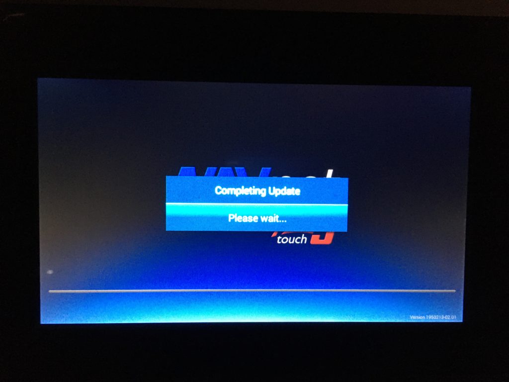
A note about the V2 software update. The provided instructions are highly inaccurate. There is NO check that the update has already been applied. There is NO on-screen prompt to remove the USB drive. The unit will happily restart at the end of its update and proceed to apply the update over and over until the universe fades into heat death. So you must BABYSIT the software update and watch it like a hawk. After the screen that says “Completing Update” / “Please wait…” the unit will beep five times then restart. You must IMMEDIATELY remove the USB drive just after the restart! Otherwise you’ll be forced to relive the update again and again until you get it right—like a wholly frustrating and unentertaining version of Groundhog Day. This experience did not leave me feeling inspired about Furuno’s software engineering skills. By the way, don’t forget to perform the required factory reset after the update. (And good luck finding the TZT3 instructions for this!)
I will say though, the ability to customize the startup splash screen is quite nice.
Radar
DRS4D-NXT. This is the main attraction for this display, but I’m still waiting for the radar unit to arrive. Until then there’s not much to say. I’ll update this post when I have some first-hand experience.
Chartplotter
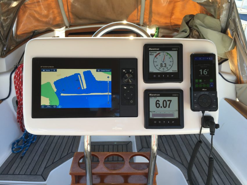
General. Seems to function fine as a chartplotter. It’s fairly intuitive and easy to use. Scrolling is smooth, and while it could be zippier, it’s not underpowered. (Furuno’s web site likes to carry on about how fast the “time zero technology” is, but frankly, it’s not particularly impressive if you’re used to a well-designed modern navigation app like SEAiq, which, as far as I’m concerned, is the gold standard.) At 1280 x 720, the display resolution is nowhere near as good as a recent tablet device—but it’s good enough.
AIS / Vesper Cortex. The display shows AIS targets without having to do any special setup. It works as you’d expect. Each target has a triangular icon, as well the associated MMSI number or, if available, the name. You can tap on a target to get more information. Each target also has a true course and speed vector shown. The display allows you to configure alerts for CPA and TCPA, but it makes more sense to do this in Cortex itself (so that it can alert even when the display is off). AIS targets come in via the NMEA 2000 network, so it does take some minutes for (especially class B) targets to fully populate. (This is in contrast to the Cortex Onboard app, which can populate all targets more or less instantly.)
Satellite images. Satellite imagery of the United States coastal areas is available for download in the required proprietary file format free of charge from furunousa.com. Each imagery file is roughly 2 GB in size, and there are limits to how many imagery files can be loaded onto the display at a time (I think it’s maybe four). Nonetheless it’s a great boon to have the imagery available offline for navigation. You can easily control whether or not the satellite image layer is displayed. I do wish the images were higher resolution, but this is a great start.
Fish finder. I do not have a compatible transducer, and I have no interest in finding fish, so I did not evaluate this functionality.
Q&A
- How do I load my own S-57 charts? You cannot. Yes I know it boggles the mind and is utterly flabbergasting that this international standard chart format is not supported. Only those S-57s that are packaged into their proprietary format may be used. The marketing materials touting S-57 charts are disingenuous at best. If you have your own hard-earned portfolio of charts in this—have I mentioned?—well-known, elsewhere well-supported international standard format, forget it. See this forum post by yours truly. Frankly I find the rampant vendor-locking efforts in this industry to be saddening and disheartening. It serves only the pocketbooks of the corporations and not their customers, us sailors, who are the ones out there depending on this stuff for our safety. Truly shameful. Shame on you Furuno!
- On the power cable, which wire is positive and which is negative? Once again Furuno bucks both standards and common sense, inexplicably choosing to provide a power cable with one white and one black wire. And with absolutely no irony whatsoever, the installation manual completely avoids telling you which is which, yet states plainly, “When connecting the power supply, connect the positive and negative terminals correctly.” Thanks! Well, white is positive and black is negative. Source: this forum post and my own installation.
- What is the maximum useable SD card size? Presently unknown – however, TZT9F comes with a 256 GB card pre-installed, so it must be at least this much.
- What is the display resolution? 1280 x 720 (source).
- Does the SDU-001 work with the TZ Touch 3? It’s believed so, although I haven’t personally tried it. See “SD Card Slot” and “Optional Equipment” here.
- How do I update the firmware? See the “Software Downloads” section here. BUT also see “A note about the V2 software update” above to avoid heartache and existential misery.
- Where do I get the full manual? Download the full PDF here (or see this page).
- Can I connect the Airmar P19 or P79 depth transducers to the MFD? I have not seen any evidence to suggest this is possible.
- Why is it continually rebooting when the NMEA 2000 network is powered on? I don’t know either, but it stopped doing that after the V2 software update. No, the release notes for the update didn’t mention anything along these lines.
- Which NavPods can house the TZT9F? I used the NavPod GP1170 and, while it does fit, the power cable at the back of the unit gets sharply bent against the back of the pod. Because this 9″ display unit is so deep, it’d be nice if Furuno offered 90 degree elbow adapters for the connections in back. When mounting, be sure to position the unit so that the power connector will not conflict with the raised areas inside the pod into which the pedestal guard tubes fit. In an email conversation with Ocean Equipment, makers of NavPod, they expressed confidence that the GP1920 model would also accommodate the TZT9F’s significant depth. On this topic, I can wholeheartedly recommend the NavPod: they’re robustly built, and Ocean Equipment was supremely responsive and helpful with my inquiries. If there’s enough interest, I’ll write a separate article about my NavPod experience.
Savage!
Yeah. Perhaps too harsh? For all I know it’s the same story with all MFD vendors. It’s just so angering and disappointing.